|
Lunch in the Bay of Florida (27 kb) |
It's been a long haul today, but finally we are approaching Shark Point, Elizabeth in her single Klepper Aerius Expedition folding kayak and Surain and I in our double Nautiraid Raid Expedition folding kayak. It is definitely later than planned, and we have been navigating in the moonlight for a while. We have been trying to speed up our progress by towing, first time we've ever tried it, by trading positions in the kayaks in deep water, a second first, and now find ourselves paddling in darkness, a third first.
All we know about this campsite is that it is situated somewhere on a long and narrow peninsula. Since all the land mass around us is mangrove swamps, there are only two options for spending the night: Finding the Shark Point campsite or trying a night in the kayaks. We are definitely giving all our energy to finding the campsite.
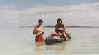
Near the end of the peninsula there is a narrow clearing, with an uprooted mangrove next to it. Or is it just some more swamps? It is hard to make out details in the narrow flashlight beam. As we draw closer, a swarm of hungry mosquitoes welcomes us. But we delight at all the fire-flies. Strange noises and movements near the shore attract our attention. Surain, who is nearest, offers a guess that it is a crocodile. The only remnant of North America's crocodile population dwells in Florida Bay. Elli and I watch as Surain starts touching the "thing" with her paddle. Surely she must have decided that we are dealing with something less formidable than a crocodile?
|
Horseshoe crabs (75 kb) |
Yes, after a while she exclaims "horseshoe crabs"! They are all over the approach to the shore. Horseshoe crabs look strange and pre- historic. The top of them is like a 1' wide half-shell with two narrow eyes at one end and a long, hard tail at the other. The comparatively small body and unimpressive pincers are hidden from view. How are we going to get ashore without walking over the bodies of all the crabs? Elli is bravest, and forces her Klepper onto the land, leading the way over the crabs. We have all been dressed in shorts and T-shirts, a fair meal for mosquitoes. We quickly don more clothes and bug repellent. It is amazing how quickly you can pitch a tent when you need to! The blood-drawing insects are loud outside, but we are safe in the tent.
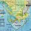
The Everglades National Park is located at the southwestern tip of mainland Florida, and includes a fair chunk of surrounding waters. The inland waters are subject to the tides and have brackish water. There is no freshwater supply except at the ranger stations.
Except for the portion in Florida Bay, you have to apply in person for a back-country permit - required for any overnight stay - no sooner than 24 hours before the start of your trip. Park rangers had assured us that getting a permit would be no problem at the end of November, which is the end of the rainy season. The high season was still several weeks away. We had flown down to Miami with all our gear hoping this would be true. As far as we know, there is really no other way to do it - get prepared, fly down there and hope for the best.
Our plan was to paddle the "wilderness waterway", a 99-mile water trail between Everglades City in the north and Flamingo in the south. It is possible to rent canoes and sit-on-top kayaks. Most paddlers seem to use canoes. However, kayaks seemed more appropriate for the conditions we encountered - quite a bit of open water and strong winds.
A second anticipated problem was getting to the park itself. There is no public transportation. Renting a car was pretty much out of the question for us, because a single car could not hold the three of us and all of our gear. Moreover, we would have to leave it at one end for almost two weeks, then find transportation back to it after the paddle.
Instead we opted to go down to Key Largo, easily reachable with Super Shuttle or Greyhound Bus Lines. An outfitter took us the six miles out to North Nest Key, a quiet little key where we could assemble our kayaks. From here, it was about a day and half to paddle due west to the Flamingo Ranger Station. But we were glad to have the opportunity to explore Florida Bay, even though it lengthened the trip. Permits for this part of the park can be obtained by phone (and once we arrived at Shark Point we realized there wouldn't be much competition for this poorly developed site).
|
Waiting for transport to North Nest Key (83 kb) |
|
Chart (108 kb) |
Yesterday we battled head winds most of the day, slowing our progress to Shark Point. But today there is an easterly from behind us. Elli quickly raises her sail, while we prefer to paddle a bit longer. Lots of fish jumping or stirring up the water. We have been amazed at how shallow the waters are in the bay - about two to five feet even at expanses of four miles or more. Today it is even shallower, and our paddles start to hit bottom.
In our infinite "wisdom" (how can you be so dumb?), we abandon the paddles and sail as well. A big fish hits our boat, making the hypalon hull quiver several times. We are surprised at the large amount of birds wading in the water around us. At about the same time, our boat comes to a sudden and complete stop. It is quite difficult to make any headway using the paddles. I try to get out and push, but quickly realize there is no bottom to the mud. So I sit on top of the kayak, pushing with my feet to lighten the load, while Surain pushes with her paddle. We get really sweaty before we hit deeper water.
Fortunately we get our back-country permit at the Flamingo Ranger station without hassle, and don't have to make any adjustments because of already booked campsites. This is where you have to get the permit in person and not more than 24 hours before the start of the trip. The passage from Flamingo Bay to Buttonwood canal leading north to the inland waters is blocked by a concrete wall. The short portage around this wall is an unexpected delay.
After the portage we fill up with fresh water, there won't be any until the end of the trip nine days later. Somehow we manage to squeeze in 20 gallons of water into the two kayaks, enough for ¾ gallons per person and day. As we head out at 3pm, an old man watching us tells us it will take us six hours to get to our campsite. We hope not, we will get hungry long before 9pm.
Signs warn us not to disturb the manatees, the only surviving "sea cows" of the world. They come into the park when the waters in the Gulf of Mexico become cold in winter. But we don't see any. We do spot an alligator lazing away under a mangrove tree on the shore. We probably see more powerboats here in this canal than we do during the rest of trip. Great blue herons take off when we get too close, slowly beating their big wings. There are also many white ibis, and these aren't quite as shy.
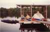
Though we are making good headway paddling and sailing, we soon realize that we are in for another moonlight session. Yesterday was just a straight shot between two points, but today is more challenging between the mangroves. I sit with a flashlight, compass, chart, and a watch for dead reckoning. The dark shoreline is pretty easy to make out. As we reach the bay where South Joe River Chickee is located, we set our course at 260 . Soon we are rewarded as the chickee comes into view out of the black. And is only about 7pm.
It is a welcome sight. A chickee (an Indian word meaning thatched hut), is a raised platform over the water with a roof over the platform. You tie the boats to the chickee, pitch the tent on the platform, don't need a rainfly, and get a clean surface. The drawbacks are lack of space (no room for jogging or hiking), and it is easy to drop small things between the planks irretrievably into the water. This chickee is out a ways from the mangrove shore, so there are very few bugs to bother us. What a difference from Shark Point yesterday!
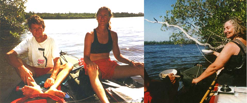
I dig out the campstove, and mix a can of crab meat, mushroom/onion soup mix, and bulgur together. From our generous spice "cabinet", I pick some tarragon, coriander, and oregano. Dried shiitake mushrooms, fresh garlic and fresh onions and carrots also make it into the pot. We open a precious bottle of cabernet sauvignon (because wine makes you dry out, it forces you to drink even more fresh water, so we had a very limited supply of wine along).
We hear the crickets playing, and now and then heavy wings from a bird flap. But what is there in the water? However much we try, we can't see what is causing the sound, kind of like a human swimming. We learn later that it is most likely dolphins feeding. We spend a very enjoyable evening, basking in the light of an almost full moon.
The next day is windy, but mostly in our favor. The open waters we encounter are surprising, we had expected much more confined waters. Though it is generally only three to six feet deep, we can't see the bottom due to the murky water. Several bottlenosed dolphins swim by our lunch site at Oyster Bay Chickee.
In Shark River we encounter head currents and head winds, so it is a struggle for us to make it to Shark River Chickee. We are disappointed to find it next to shore. This will undoubtedly mean more bugs and we'll have to worry about raccoons. Time and again we have been warned about the raccoons, who will do anything to get to your food. Since there is a shortage of fresh water for animals, they have learnt how to recognize water containers and will bite through all but the most sturdy of them. But aah, there is an outhouse with a door. That is where we store all food and water during the night.
The mosquitoes seem glad to see us. Their brethren, the no-see-ums, are just as thick. Each bite is not as bad, but they are very numerous and bite much faster. Being so small, they don't seem to bite through clothing, though. I find it most irritating in the hair and wear a hat whenever these small critters are around.
After dinner, the bugs excuse themselves and go away. Obviously even they are mindful of Surain's and my eighteenth anniversary. The moon is full, a giant shining disk high in the sky. We figure you only get a full moon on your anniversary once every twenty-eight years. It is a magic evening. The crickets are loud, there are big birds flapping their wings in the darkness, we hear the dolphins feeding. Water is running from many places, caused by the falling tide. There are other sounds we don't understand. One is like the one produced by a grizzly- sized owl. What kind of sounds do alligators make?
|
Elli and Chickees (37 kb) |
I wake up around midnight. The mosquitoes are back, they are very noisy just a few inches from my face, with just the thin tent fabric as a shield. The crickets have stopped, but what sounds like frogs have taken over. There are some other noises, too, kind of like air bubbles in water.
I notice that Surain and Elli are sitting up and looking out towards the kayaks. It is hard to see in the flashlight beam through the netting. Finally I grab a flashlight and run out and shine it at the kayaks floating in the water next to the chickee. At first glance everything looks fine, but then I exclaim with horror "our kayak is full of water!".
It is indeed true. How could it have happened? flashes through my mind. Could an alligator have bitten through the skin? However, this is no time for idle thought. The rear cockpit is submerged, so pumping won't do any good at this moment. Surain and Elli bend down to remove drybags from the kayak. There doesn't seem to be anything floating in the water. I grab a rope, attach it the rear carrying handle, run it above a chickee ceiling beam, and try to raise the stern. A paddle is stuck in the way, but once I remove it I can get the rear cockpit above the water.
With three people pumping and bailing, it doesn't take too long to empty the kayak. It seems to be floating just fine. We drag it out of the water up on to the chickee. With the rush of adrenaline out of our systems, we realize we haven't been alone. Then I remember listening to the sound of a million mosquitoes from the relative safety of the tent. They have just had the meal of their lifetime, as we rushed out of the tent very lightly dressed. Each mosquito inserts a little bit of poison into the blood. With probably many hundred bites each, our bodies feel tingling and strange. We retreat to the tent. Ah, the itching! With utmost self-control we refrain from scratching and feel better half an hour later.
As we ponder what could have caused the kayak to fill with water, Surain puts forth the theory that the side of the kayak closest to the chickee got stuck at low tide (reminding me that I had some difficulty removing the paddle), and the rising tide caused only the other side to come up, thus tilting the kayak on its side. Indeed, as we inspect the chickee next morning when the tide is low again, we see some vertical boards ending between the high and low water marks. The paddle attached to the deck could easily have got stuck there. We were lucky not to lose anything and there is no damage to the kayak.
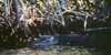
We have been disappointed not having seen any alligators except the one basking in the sun close to the ranger station. People had informed us they would be easy to spot. We keep looking through our binoculars but to no avail.
There is a log floating near the shore, covered with mud. Or is it? What are those two round things popping out of the water, and how come it is moving against the current? It is an alligator! Surain and I are excited and don't mind getting close, while Elli displays a healthier respect. We start seeing more of these "floating logs", and eventually start spotting them on shore as well. The alligators seem quite timid, and slide into the water as we approach. Some remain visible on the surface, while others disappear completely under water, leaving you to guess about their whereabouts.
Alligators are getting so common, that we are surprised we didn't see any the first day and a half. Once the stern of our kayak is rocked by a powerful movement and we feel a bit vulnerable. Was that an alligator tail we disturbed?
Our best view is in the aptly named Alligator Creek. We come on several asleep in the sun, not noticing us at all. Even when we snap pictures from only about 30 feet away, the alligator doesn't stir.
|
Alligators (46 kb) |
The going gets much slower as we travel upstream - first Shark River and later Broad River. At times we have both the river's current and the wind against us. We may have misjudged the timing of the tide in Shark River, but we feel pretty sure we travel Broad River on an incoming tide and thus have the tidal current with us. Still we drift backwards when we put the paddles down to rest.
As we struggle and sweat, we think we understand why the guide books and the rangers told us that most people paddle from north to south, not the other way that we are doing. One ranger told us it is because of the mostly northerly winds, but as we see the current going the other way, we have our own explanation.
Some mangroves stretching far out from the shore offer welcome resting spots. The mosquitoes will swarm out and attack if you get too close to shore. As we stop for lunch at one of these spots, we are glad to be in stable folding kayaks, since we can move up on deck and stretch out on top without risking tipping the kayak.
People had told us we had to do the Nightmare to experience the real Everglades. We weren't quite sure what the Nightmare was all about except that it was a narrow stretch of water, it should only be attempted at high tide and only in small boats.
It wasn't very far to go from Harney River Chickee, where we had spent the night with many mosquitoes and no-see-ums, to the Nightmare. Since it was still low tide, we were to take our time, have lunch, and wait for high tide. We were quite excited about this opportunity to see the "real Everglades".
The tide was still going out as we headed north. It didn't take us long to reach Broad Creek. A marker pointed us west to the waterway, still several miles away from the entrance to the Nightmare. As we turned our kayaks left, we were surprised to see how narrow Broad Creek was. The mangroves from each side reached over to form a canopy over the narrow river. There were roots sticking up everywhere. The special smell of low tide mud was all over.
The mosquitoes were glad to receive us, they appeared under-nourished. We quickly donned spray-skirts, paddle-jackets, hats, and bug repellent. Better hot than bitten! It now became apparent why people had recommended us to bring face netting, it sure would have been nice in here. The river twisted and turned. We often got stuck and had to back out to try a different route. Many times we powered through using our paddles as poles. After a while we took the paddles apart and only used half a paddle in a canoeing fashion, much easier.
The tide was still going out, so the current was with us. This may seem like an advantage, but it was not. If the kayak got stuck sideways against a root, it was next to impossible to back it up against the current. Are we really where we think we are? I double-check the chart several times. But everything fits, including the marker pointing this way, except the two thick lines giving an impression of a bigger river. A fishing pole hanging strangely in the mangroves indicates that someone else has been traveling here before.
As we work our way through, sweating, poling, backing up, trying again, brushing off mosquitoes, we sure hope we don't get stuck here with all the bugs. Right now it seems like a real possibility. How could anybody go through here with a powerboat? It certainly would be impossible right now. The river broadens slightly. Is it over?
Not yet. More dense canopy, roots, muck, getting stuck. What is this if not the Nightmare? How could anything be worse than this and still allow us to get through? We half expect giant alligators waiting for us around the next corner, salivating. Slowly it dawns on us that this stretch of Broad Creek must be part of the Nightmare, we just hadn't expected it yet. And because of this it comes as a shock.
Would this have been easier at high tide, we wonder? With the water three feet higher, we wouldn't get stuck. But then, we wonder, would there have been enough headroom? In a later discussion with a ranger, he convinces us that, indeed, high tide would make it a lot easier. The river broadens again, but this time it stays broad. "Our" Nightmare is over. We are out of it and can sigh in relief. It is nice to remove spray-skirts and all those extra clothes again.
As we study the chart, we realize that the warning that the Nightmare should only be attempted at high tide also applies to the stretch of Broad Creek we have just powered through. We quickly rename it to Nightmare II. When Surain quietly suggests we avoid the real Nightmare and instead make a small detour through the Gulf of Mexico, we all nod in agreement.
Out in the Gulf we find a sandbar about half a mile from shore. We eat our lunch standing next to the kayaks in a foot and a half deep water, then wash our bodies, swim, and de-mud the kayaks. It is like heaven!
We paddle north along the coast. The gulf is incredibly flat. There are ospreys at almost every point we pass. As we get closer to Broad River, where we are supposed to head inland again, small mangrove islands pop up. On one there are many big pelicans hiding on the branches in the greenery, on another many cormorants fight over space on naked roots, and on a third beautiful terns line up in perfect formation. Every now and then we see great blue herons.
More and more islands. We expect markers to show us the way to the river. On the chart there is an obvious route. But not so in reality. Some large green areas, that I had taken to be tidelands, turn out to be just a maze of islands. At some point we need to turn east. But where? We continue a bit further. We are lead almost north and start to get concerned.
Elli brought a GPS, which we haven't really used yet. But now it comes in handy, as we retrace our strokes. Where the GPS indicates the river should be, we turn east. It doesn't take us long to arrive at the northern end of the Nightmare. I stare at the sign in disbelief. On the chart there is just the Broad River and then a few large islands a couple of miles west. But from where we came, there are islands everywhere.
Not to offend alligators, mangrove, the Nightmare and others, but our strongest memory of the Everglades will be the birds. From our first afternoon, when we were taken to the North Nest key and shown pelicans, the magnificent frigate bird, so aptly named with the males' red pouch, and the beautiful roseate spoon-bill, we have been rewarded with the sight of great birds all the time.
We recognize with delight the great blue heron, so familiar from the northwest. But here there is also a white form of the same bird. Then there is the lesser blue heron, smaller and not as colorful. We love the tri-colored heron, so gracious with its long neck. Running around in the mangrove, we have often spotted the yellow-crowned night-heron and probably also the black-crowned night-heron.
The white ibis is everywhere. The immature is much more colorful. We recognize two kinds of cormorants. And there is the anhinga, quite common. It looks like a cormorant with an extended neck, and is adorned with beautiful tail feathers.
The great egret and the snowy egret. Both white with black legs, but one has a yellow beak and one has a black beak. A couple of times we spot the endangered wood stork. We think we saw a bald eagle the first day, but may have mistaken it for an osprey, an abundant bird. Big black vultures hover overhead most of the time, and we also see turkey vultures. When we passed the Darwin campsite, where there were tents but no humans, four great vultures sat on the roof of the outhouse.
Beautiful least terns. Ring-billed gulls. An immature Franklin's gull landed on the beach not five feet from us and followed us around for a while. Dowitchers standing in formation on the beach. We laugh when a wave hits the first one, as it will quickly scamper back to the tail. American oystercatchers with their salient red beak. Belted kingfishers chirping and diving everywhere. Brown pelicans diving for fish, so funny-looking as they plop down on the water with a big splash. They also have a white cousin.
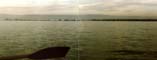
The last morning we headed out very early. As we neared the long sandspit extending from the Lesser Pavilion Key, we realized there were many white birds out there. As we drifted closer, we could see they were all white pelicans. There must have been easily a thousand pelicans on this small sandbar, pelicans looking at us, walking in formation, swimming in formation. We could only sit in our kayaks silently, looking at this great display of nature in awe. It will be a memory forever.
|
White Pelicans (56 kb) |
After we have negotiated Broad River against the current and the wind for a couple of hours, the waters open up and we are glad to be out of the current. Rodgers River Bay Chickee is a very welcome sight (when we finally find it, it is misplaced on the chart), away from the shore and the bugs. At Broad River campsite (the only non-chickee night we spent inside the Everglades), there were so many bugs that we spent most of the evening in the tent. Here at Rodgers River we also meet the first other party of paddlers. Steve, a volunteer ranger, and Laura and Helene are traveling south in two canoes. We exchange experiences and tips, though Steve, who has already done the wilderness waterway twenty- six times, hardly needs any advice. He tells us that we won't encounter any more no-see-ums, since they are only in the southern part of the park. We won't miss them!
Chance has it that they have one car too many parked at Everglades Ranger Station, where we are heading. So Steve just hands us his keys and asks us to drive his truck to Laura's home just south of Miami. Our return transportation problem is taken care of.
The moon rises later now and is no longer as full, so both here and at the following equally nice chickees at Plate Creek and Sweetwater we get wonderful starry skies with the milky way clearly visible.
The next day powerful easterly winds stir up sizable waves, convincing us to don the sprayskirts. We are traveling through fairly large bays connected by surprisingly narrow waterways. In some of these channels the mangroves form a canopy. The graceful tri-colored heron is often seen, as is the anhinga with its beautiful tail feathers. And we had thought that it might be boring to paddle around the mangroves all the time! Not so, we still marvel at how nature can create such a varied land and seascape from so few parameters.
People had told us we had to go "outside" (meaning into the Gulf of Mexico) and see some of the keys. So we had reserved Pavilion Key for the last two nights. As we are heading down Chatham River on a favorable tide, we listen to the weather-radio. Reception has been so- so most of the time in the park, but now it is fairly clear. Small craft advisory with 25 knot winds from the east. Ahead lies a three mile open crossing with tailwinds. Time for sprayskirts and life jackets!
Park brochures had warned us that the shallow waters get quite rough even in moderate winds. Based on that, I suspected we would have a challenging ride. However, we had rather the opposite experience. The waves never built up during the first half of the crossing, when the water was only three to four feet deep. When the depth increased to about eight feet, the waves got bigger. The bottom rose up to about four feet again closer to Pavilion Key. Here the waves twisted and contorted for a while, with one wave breaking over our kayak. But this was not serious and only added excitement. There was some concern when Elli lost her steering cables, but fortunately we managed to fix them.
Pavilion Key greets us with a sandspit and an excellent campsite, bugfree despite the proximity to the mangroves. A magnificent woodstork soars above us for a few moments. Many pelicans dive for fish. Least terns and ring-billed gulls line up at the end of spit, facing the wind. An immature Franklin's gull alights not even five feet from us.
Our day of rest (no paddling!) is spent hiking around the island at low tide. The other side is a heaven for wading birds. We see snowy egret and greater egret, great blue heron, great white heron, lesser blue heron, white ibis. There are also many pelicans, oystercatchers, terns and gulls. This island is also the place where we notice lots of raccoons. We had uneasily followed recommendations to put all of our dwindling food and water supply in the tent, but the raccoons leave it alone.
Paddling distances (in nautical miles):
Day 1 (North Nest Key - Shark Point Ground Site)    17 + 1
Day 2 (Shark Point - South Joe River Chickee)       18
Day 3 (South Joe River - Shark River Chickee)       12
Day 4 (Shark River - Harney River Chickee)          10
Day 5 (Harney River - Broad River Ground Site)      11
Day 6 (Broad River - Rodgers River Bay Chickee)     10 + 1
Day 7 (Rodgers River Bay - Plate Creek Chickee)     12 + 4
Day 8 (Plate Creek - Sweetwater Chickee)            11
Day 9 (Sweetwater - Pavilion Key)                   10
Day 10 (rest)
Day 11 (Pavilion Key - Everglades Ranger Station)   11
Total 122 + 6 nautical miles (140 + 7 statute miles).
Mammals seen:
Raccoon
River Otter
Bottlenosed Dolphin
Other animals seen:
Alligator
Horseshoe Crab
Crab
Oyster
Ray
Turtle
Snake
Birds seen:
Least Tern
Franklin's Gull, immature
Ring-billed Gull

Magnificent Frigatebird
Brown Pelican
American White Pelican
Double-crested Cormorant
Olivaceous Cormorant
Anhinga

Horned Grebe
Pied-billed Grebe

Black-crowned Night-Heron
Snowy Egret
Great Egret
Little Blue Heron
Great Blue Heron
Great White Heron
Tricolored Heron
Yellow-crowned Night-Heron
White Ibis
White Ibis, immature
Wood Stork
Roseate Spoonbill

American Oystercatcher
Long-billed Dowitcher
Short-billed Dowitcher
Sandpiper

Turkey Vulture
Black Vulture
Bald Eagle
Hawks
Osprey

Northern Rough-winged Swallow
Belted Kingfisher
American Crow
and others
Robert afSandeberg