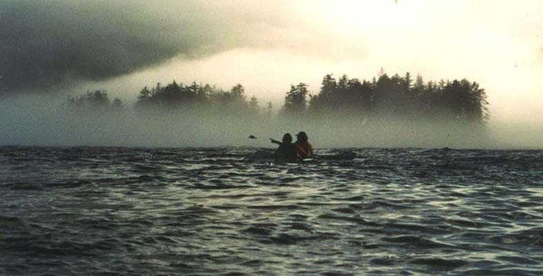
Everything was engulfed in dense fog as we were closing
in on the campsite at Benjamin Point, where we had been planning
on spending the night. This is right at the most treacherous area
of our paddle, completely exposed to Hecate Strait with
currents up to four knots. Yesterday's storm had vanished, today there
was no wind, and it was slack tide. I suggested to the others
that we take advantage of the moment of calm and continue to Houston
Stewart Channel now. Tomorrow a new storm might materialize,
blocking us from reaching
our goal at Sgan Gwaii (Ninstints). So we pushed on,
despite the fog. It was eerie listening to the breakers crash
on the beaches without seeing anything. The island curves slightly,
so I relied on the compass to give me a pretty good idea where we were
on the chart.
Suddenly the fog started lifting around us. The light
was incredible as some of the ocean came into view with high
mountains behind. Eagles were chirping from treetops that floated
above the clouds. As the current started building against us
and we had a following sea, the waves got quite steep. Fish must
have been plentiful, for gulls were loudly flocking
in the currents. We paddled hard through tide rips,
as we rounded the point and headed towards a beautiful beach.
The grass beyond the beach was velvety smooth and it was nice
to sink into after the day's long 19 nautical mile paddle.
Paddling the Queen Charlotte Islands was a dream come true. We
had perused several books and marveled at this intriguing
Northwest Coast native civilization. We had read The Hidden Coast
by Joel Rogers and then been even more drawn by the idea of visiting the
native sites from a kayak. We were relatively new at kayaking. Could
we paddle there? We decided to give it a try. With us were our
good friends Tanya Demarsh from Seattle and Christian Jutvik
from Sweden. Christian had done some paddling in the Stockholm archipelago
and added some welcome paddling experience to the group.
Our poor little Toyota Corolla had to carry four adults, two double kayaks and all the food and equipment we needed for a ten-day paddle. Some friends had loaned us a Seascape Double kayak and we had rented a double Klepper. It took us three days to drive from Seattle to Prince Rupert in British Columbia, stopping along the way at several native heritage sites to observe the monuments and totem poles left behind.

An overnight ferry carried
us and our car across Hecate Strait, renowned for its stormy
weather. In Queen Charlotte City we picked up kayaking permits
and bought a few more supplies, then took another short ferry,
visited the logging company that owned the land we had to cross,
and drove another hour and a half. At one p.m. we were finally at
Moresby Camp, where we planned to launch. The people at the logging
camp had told us that the weather had been unusually good with
calm and sunny days. Unfortunately for us, that was not to continue.
It took us a while to make a boat out of the Klepper hypalon skin
and many wooden pieces: keel, floorboards, ribs, longerones, etc.
We had no experience filling kayaks with all the paraphernalia
of an expedition, but we quickly started appreciating the room the
Klepper offered. This 17' kayak easily held more stuff than the
20' Seascape.

As we were loading our kayaks, an easterly wind started blowing. It picked
up speed and we soon saw white caps. The weather forecast warned of
a small craft advisory. What happened to the balmy weather? Reluctantly
we decided to forgo visiting Skedans. This ancient native site
on the east side of the islands is completely exposed to Hecate Strait.
 --
Smaller picture (40 Kb)
--
Smaller picture (40 Kb)
We struggled a bit against the wind before turning south between
two islands. We found a campsite marked on the chart and pitched
our tents there. It soon started raining, and the wind howled fiercely
all night. In the morning, we hovered in a small shelter nearby
to eat breakfast in relative dryness.
The rain continued, but the wind sounded somewhat less threatening
as we got ready for departure. Looking at the kayaks
on the beach and the water far away at low tide gave us the first
vivid example of the magnitude of the tides here. It was a long
way to carry the kayaks and then all the dry bags in this downpour.
We were quite wet by the time we climbed into the cockpits and put on
the skirts, protecting everything below deck from the rain.
It rained all day until late afternoon. By that time the wind
had died down, too. The Queen Charlottes had already given us
the second example of its peculiarities: the rapid weather changes.
If you don't like the weather, wait half a day and it will be
completely different - for better or worse. Our campsite that night had
extraordinarily beautiful forests and we quickly forgave the weather
for its initial downpour and storms. We had arrived at the boundary
to the Gwaii Hanas National Park.
In the next couple of days we visited two ancient Haida sites with
resident native caretakers: Tanu and Windy Bay.
Windy Bay has the most beautiful temperate old growth forest
I have ever seen. There were magnificent stands,
especially of Sitka spruce. This place is very significant in
the history of the national park. All of the Queen Charlotte Islands
used to be open for logging. One day the logging truck showed up at Windy
Bay. But the Haida flatly told the loggers that they could
not log here, since it was sacred land. The loggers pointed to
a signed agreement allowing them to log everywhere.

This started a long, drawn out fight, eventually resulting
in the fortuitous creation of the Gwaii Hanas National
Park, covering the southern half of the islands. Much had been
logged before the national park was created, leaving ugly sores
in the landscape, but luckily there was still much left unscathed.
We delighted at seeing many deer running around Windy Bay. The caretakers
were especially friendly here, inviting us in to their house and
offering us tea and snacks.
As we got more used to paddling, it was obvious that
the two kayaks had very different temperaments. The Seascape seemed
light and easy to paddle. The Klepper was heavier - only partly
because it was laden heavier - and slower. It has negative rocker,
so it goes very straight, but it also tends to submarine when paddled
against ocean waves. The soft skin makes it similar to paddling
the Eskimo baidarka in certain aspects. It handles ocean waves very
softly and you can clearly hear the waves against the hull.
The Seascape was very different and met the waves harshly.
Despite the additional effort of paddling the Klepper, we all
preferred to be in it, where we "felt as one with the sea".
The water was surprisingly warm. Had we had sunshine,
we might have gone swimming. How could it be so much warmer here
than in Puget Sound, which is so much further south? If we were
to flip, we would survive a long time, and that was comforting to know.
The color of the water seemed to change with every waterway.
We saw ice green, dark green, clear bright blue, deep dark black.
There were many areas thick with kelp bulbs floating at the surface
with their lovely long fronds dancing in the currents. They
were so prominent as to be marked on the charts.
After three days of paddling we were getting close to Hot Springs
Island. A new storm had arrived and the rain was coming down
heavily. The strong southwest wind was in our face - it always
seemed to be in our face - and we had to paddle with a tight grip
and determination to reach the island. But that struggle was soon
forgotten as we slipped out of our clothes and into the hot water.
There are several pools from the hot springs
here, some large enough to swim in. We started with the biggest
one, with breathtaking settings above the trees and mountains
all around us. In our planning we didn't think we would stop
at the hot springs as we'd heard about the overuse and abuse that
some visitors had wrought on the place, but were very glad we changed our minds.

The sun - YES, it was a little bit sunny! - was sinking lower
and it was calm again. So we didn't hesitate to do the
four-mile open water crossing across Juan Perez Sound to Moresby
Island. Far in the distance we could see a pod of orcas
spout, and much closer to our kayak a shark surfaced and briefly
circled around us. Surain suddenly imagined that we could outpaddle
a shark and leaned heavily on her paddle in front of me. But that
didn't last long, and we soon resumed the easy paddle across
the magic sea.
We did not know of any campsites on the other side, so kept our
eyes peeled for possible spots. A bay on a small island
looked very inviting. To our delight we found ourselves at a
stand of old-growth trees. We weren't phased that there was
no room for the tents, but they did look rather awkward squeezed
together with no room to stretch out. The tarp protected us from
the quiet drizzle falling at dinnertime.

The tide was too low for us to get out the next morning, so we
spent a few hours exploring the kelp beds and the myriad of sea life
revealed by the low tide while we waited for the tide to come in.
The paddle to the Dolomite Narrows appeared to be an easy one,
so the two women hopped into the Seascape. Then we paddled out of the
narrows into open waters, and the wind chimed in from the southeast as
usual. No, it was not to be an easy paddle, it was the hardest so far.
After twelve miles of fighting the wind, Tanya and Surain rolled
out of the kayak onto the beach very exhausted. Rain and sun had fought for
hegemony all day today. But this was an incredible sight, with
sea anemones, starfish, shells, small crabs, and many other delightful
creatures.

We had been warned about the resident bear here, so we walked a long
way down the beach to a little shelter where we could secure the food
at night. The bear rumbled through camp at night and sniffed at our tents,
but it ran quickly away when I ventured out for a better look. We finally did
get to see him the next morning across the shallow narrows.
When we slipped into a kayak to go for a closer look, he disappeared.
We had an easy seven miles to paddle before
lunch. Well, it seemed easy before the wind had a word
or two to share with us. The white caps grew bigger and bigger.
A sailboater was concerned seeing us bob up and down, but we smiled
and waved him on. It wasn't yet so bad. But Surain and I struggled
as hard as we could in the Klepper to make headway against
the wind. Slowly, slowly the beach on the other side came closer,
but o so slowly! As we finally made it across into the bay, the
wind was funneled even more and it seemed like the paddles were
about to be ripped out of our hands. We grabbed them hard and
dug into the water to make the final approach to the beach. No,
we wouldn't paddle any further this day. This was my hardest day
of paddling despite the short distance.
It started raining, and the rain soon came down heavier
than ever. We sat under the tarp and collected rainwater for
drinking. No thank you, we did not need quite this much! But
maybe the sky finally ran out of water, because after this day
we had no more rain during the trip. We put heavy rocks on all the
tent pegs that night to hold them against the power of the wind.
I couldn't fall asleep listening to the flapping tent, until it
finally died down long after midnight.
The wind was fortunately much calmer the next day.
We had a long paddle ahead with no islands to shelter us from
Hecate Strait. Big swells soon met us. It took us a
while to get past Ikeda Point fighting strong currents.
There was some discussion about seeking shelter, but there were
crashing waves on the beaches everywhere we looked. Where could we land?
Instead we headed for a small island that lies a ways offshore and
exhilarated in the open ocean, fighting the waves and the wind,
and feeling at one with nature.
The island had one little cove with reasonably small waves, and here
we lifted the kayaks up on some rocks (there was no beach). We enjoyed
the rest and lunch as we sat gazing at the main islands far away. Meanwhile,
the tide sank lower and lower without our noticing. The little ledge
with the kayaks was high above water when it came
time to leave. It took quite an effort to lift the loaded kayaks down to
the water so we could paddle again. The wind had now died down
completely and there was only the swell to enjoy and contend with.
In the direction of our paddle, we noticed a big fog bank drawing closer.
Ninstints
What was that blinding our eyes? Sunshine! There
was not a cloud in the sky. Quickly, we started emptying the
drybags, spreading our clothes on the rocks and logs to dry in the sun.
Even in drybags, things eventually get moist when it rains all the
time. We had made an effort to keep our camp clothes dry and always
switched to the kayaking clothes - always wet it seemed - when
getting into the kayaks. Matches had been the hardest to keep
dry, though we had had them hidden in many different
places. But now everything lay out in the sun drying.
We rigged up our shower attachment and we all went through
a well needed cleansing. And then we just lay in the sun, enjoying life.

It was already three in the afternoon when we and our kayaks were heading
westwards towards Ninstints. Funny thing, with the nice weather
returning, the wind was now coming from the northwest again -
and into our face! Was there ever a wind from behind?
Just north of Ninstints Island and through a little
island group, the Pacific Ocean opened up. No wind but huge swells
met us. There was a great view on top of a wave crest, and then
there was nothing but water visible from the deep trough. We love
being out in a calm ocean where we feel no real danger, just a lot
of bobbing around.
Christian had picked up some fishing gear and a fishing
license, and had been trying to catch fish for several days without
success. Earlier this day he complained that the rudder had stopped
working. But on closer scrutiny it was discovered that a rock
cod was caught on the rudder! After this it seemed like he had
got the hang of it, and we enjoyed a snack of rock cod with every
dinner. In fact, we had to tell him to slow down fishing a little
when he was getting too good at it.

Our campsite was only three nautical miles from Ninstints,
so it was an easy paddle to get there. On the way we stopped
where a few rocky outcrops formed a small lagoon sheltered from
the roaring Pacific Ocean. There was kelp everywhere, and no
boat with an engine or much larger than a kayak could have made
it in there. As we listened to the waves on the outside, we noticed
that the kelp was alive. There was not just one seal, but lots
of seals watching us as we watched them. Seals are so interesting
watching, as they sit with their heads out of the water staring
at you.

There are few if any Haida sites that have as many
totem poles still standing as Ninstints has - certainly none other
in the Queen Charlottes. As we entered the passage,
we marveled at some 20-30 totem poles coming into view. These
were all abandoned in the late 19th century. Smallpox
introduced by Europeans rapidly decimated the native
population, and the survivors all moved to a few villages. Since then the
old totem poles have not been touched and no new ones have been
built. Since the totem poles act as graves, the Haida do not
believe in maintaining them as they start to decay and fall
apart.

Today there are only a few caretakers living here during the summer months,
and we enjoyed meeting them and listening to them talk about this
fabulous site. Then we walked around the island. As all places
facing the onslaught of the Pacific Ocean, trees on the west side
were bent and gnarled and many had given up their struggle to survive.
We also noted that the wind was picking up speed with many whitecaps,
but now from the northwest.
After six hours of exploring on this magic island, we decided to head back. It was - again I could say - a real struggle to fight against the wind back to our campsite. The next day we paddled back to Raspberry Cove. From there a pre-arranged, fast powerboat took three and a half-hours to ferry us back to Moresby Camp, from where we'd begun paddling ten days earlier. It seemed so far to follow our route. Did we really paddle that far?
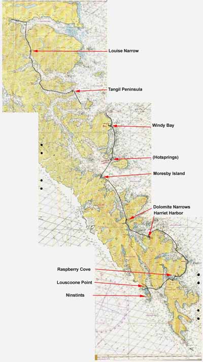
Paddling distances (nautical miles):
---------------------------------------------------------
August  4: Moresby Camp -> Louise Narrows            10
August  5: -> NE point of Tangil peninsula           16
August  6: -> Windy Bay                              13
August  7: -> Moresby Island across from Hotsprings  13
August  8: -> Dolomite Narrows                       12
August  9: -> Harriet Harbor			      7
August 10: -> Raspberry Cove                         19
August 11: -> Louscoone Point                        11
August 12: -> Ninstints -> Louscoone Point            4.5
August 13: -> Raspberry Cove                          8
---------------------------------------------------------

Total: 114 nautical miles (131 statute miles) in 9 1/2 days